Showing posts with label Petaluma. Show all posts

Monday, December 12, 2016

Another Perspective on Road Diets

Mid-Block Conflict Points for
Four-Lane Undivided Roadway
versus Three-Lane
A few posts back, I wrote about a road diet that’s being proposed for an arterial into my town, a well-traveled route into the heart of downtown used by both residents and visitors.  While not without its negatives, I think the proposal is reasonable, although other don’t agree.  Today, a friend is going to take over this space to write about the traffic engineering behind road diets, engineering that applies directly to the Petaluma Boulevard South proposal.

Bjorn Griepenburg is a Petaluma native, recently returned to his hometown after an academic career that included stops at UC Santa Barbara and the University of Oregon, concluding with a Masters in Community and Regional Planning.  After a year with Muni in San Francisco, he’s recently become the Policy Director for the Marin County Bike Coalition.

Here’s Bjorn:

Correcting Misconceptions about the Road Diet

Petaluma Boulevard South does not work well for anybody.  In its current configuration, it has four travel lanes and two parking lanes—about 60 feet worth of lanes—crammed into a 52 foot space.  It’s not uncommon to see cars parked on sidewalks or driving between the two travel lanes due to the constrained space.  The pavement is in deplorable condition.  Most importantly, it’s an uninviting and unsafe corridor for people traveling by foot and bike.

Luckily, there exists a well-established solution to all of these problems: the road diet.  Road diets have become the silver bullet of transportation engineering across the country, correcting four-lane roads like Petaluma Boulevard by eliminating a through lane in each direction and replacing them with a bi-directional center turn lane--improving safety for all users, and doing so with negligible impacts on traffic.

With the number of travel lanes dropping from four to three, a common question raised by skeptics follows some form of the following: how doesn’t dropping a lane lead to increased congestion?  I’ll do my best to explain why and how, calling out benefits of the reconfiguration along the way.

The Problem with Four Lanes – and the Case for Three

Petaluma Boulevard South’s four lanes don’t benefit anyone, drivers included.  Studies of road diets suggest that corridors with average daily traffic (ADT)—the number of vehicles that traverse a corridor in a given weekday—of 20,000 or below are strong candidates for road diets.  (http://safety.fhwa.dot.gov/road_diets/info_guide/ch3.cfm#s335)

That’s because there simply isn’t enough traffic to necessitate having multiple lanes in both directions. Petaluma Boulevard South falls far below this threshold, even under future build-out scenarios. Even if you head to the Boulevard in its peak hours, you’d be hard-pressed to find the corridor congested with cars clogging up both lanes in either direction.

Crossing and Through Traffic
Conflict Points at Intersections
for a Four-Lane Undivided Roadway
versus Three-Lane
One of the instances in which you will see cars backed up in a single lane on Petaluma Boulevard South is when a vehicle signals for a left turn and must wait for oncoming traffic to clear.  At those times, the cars behind will either queue up behind the left-turning vehicle or pass on the right. The road diet creates a designated space for left-turning vehicles, preventing these backups and the dangerous weaving patterns that they often induce.

Major-Street Left-Turn Sight Distance
for Four-Lane Undivided Roadway versus
Three-Lane
Also, as anyone who has turned left off of the Boulevard or crossed it by foot, bicycle, or vehicle can attest, the presence of two lanes in each direction can dangerously obstruct sightlines.  In my daily crossings of the Boulevard at G Street, a far-too-common occurrence involves a driver in the nearest lane stopping to allow me to cross, only to have a car speed by them in the second lane, unaware of my presence in the crosswalk. In the three-lane configuration, those crossing or turning left off of the Boulevard only have to worry about one car in each direction, dramatically improving sightlines. The Federal Highway Administration illustrations above
and to the right highlight these and other conflict points reduced by the conversion.

With each conflict point removed, the chances of a completely preventable tragedy are reduced. Studies have found crash reduction rates ranging from 20 to 50 percent along corridors similar to Petaluma Boulevard South after implementation of a “4-to-3” road diet.  (http://safety.fhwa.dot.gov/road_diets/info_guide/app_a.cfm)

Even if the road diet had negative traffic impacts—and it doesn’t—it would be absolutely ridiculous to argue against a project that makes a corridor safer for people walking, bicycling, AND driving. It’s time to start honoring our commitment to public safety through road design. In the case of the road diet on Petaluma Boulevard South, it’s a no-brainer.  – Bjorn

My recent post on road diets triggered extensive comment chains on both Facebook and Nextdoor, a conversation in which Bjorn participated.  I didn’t have the opportunity to join the discussions, but will use my next post to respond to a few of the comments.

As always, your questions or comments will be appreciated.  Please comment below or email me.  And thanks for reading. - Dave Alden (davealden53@comcast.net)

Monday, December 5, 2016

I’m Back and I Want to Talk About a Road Diet

Petaluma Boulevard South
(note truck using both 10-foot lanes)
Let me start by apologizing for my long absence from this soapbox.  It wasn't a planned absence, although in retrospect it does feel as if it were inevitable.

In my next post, I’ll talk about the reasons for my temporary disappearance after nearly five years of thrice weekly posts.  But today I have a subject of more immediate importance.

I’ve previously written about road diets, modifications to existing streets to readjust the balance between cars, bicyclists, and pedestrians.

The most common version of a road diet, one that has been implemented in communities across the country, converts two lanes of traffic in each direction into single travel lanes, a center turn lane, and, depending on the geometry of the existing street, added accommodation for bicycles, pedestrians, parking, and/or street beautification.  As long as the traffic doesn’t exceed 20,000 daily trips, these “four-to-three” road diets have been found to have little to no impact on traffic capacity.

Wikipedia provides a summary of road diets in the U.S., although the list of completed projects is deficient.

In Petaluma where I live, a road diet was implemented a few years back on Petaluma Boulevard through the heart of downtown and continuing a little further north.  As I described in the post linked above, the project was controversial.  There was significant opposition before construction and many were willing to decry the road diet as a failure immediately after completion.

The debate has largely died away, although occasional pockets of obstreperousness remain.  But by most objective and subjective measures, the downtown road diet has been a success.  Traffic counts are higher now than they were before the road diet, showing that capacity wasn’t harmed.  Traffic accidents are reduced.  Pedestrians generally report a more comfortable experience.  And bicyclists, although still bemoaning the lack of bike lanes which weren’t possible because of the narrowness of the road, admit that the riding experience is better than before. 

Encouraged by that success and motivated by the availability of grant funds that can repave deteriorating streets as a part of implementing road diets, city staff has been alert to the possibility of more road diets.

They identified South Petaluma Boulevard as a suitable project.  The work would begin at the southern end of the previous road diet and continue another mile south.  Indeed, they found that it was the road section in Petaluma that best fit the criteria for a newly announced grant program.  With staff having identified the opportunity, a City Council hearing is scheduled for December 19 to consider giving direction to city staff to apply for the grant.

As a long-time user and observer of Petaluma Boulevard South, I’m pleased with the progress.  The street needs a change.  The roadway segment nearest to downtown has four 10-foot travel lanes and two six-foot parking lanes.  Although there are places where 10-foot lanes can work, and may even be desirable, four 10-foot lanes bracketed by narrow parking isn’t one of those places.  And six-foot parking lanes, compared to more common widths of seven or eight feet, often induce drivers to park with two wheel s on the curb, diminishing the pedestrian experience.

Adding in the aging and heavily patched pavement, the street is an uncomfortable drive for motorists.  It’s even worse for bicyclists and pedestrians, especially for walkers trying to cross the boulevard from the residential neighborhoods south of the boulevard to the restaurants and riverside parks to the north.

Also, Petaluma Boulevard South is the designated multi-use path (MUP) for the SMART train that is coming soon to the North Bay.  The MUP, which was essential to voter approval of SMART, is the route by which bicyclists are directed to reach SMART stations or to tour the North Bay.  It’s an embarrassment to both SMART and Petaluma to have the MUP aligned along a road that is so unwelcoming to bikes.

Despite the logic for the Petaluma Boulevard South road diet, some opposition nonetheless arose, offering many of the same arguments that were used against the downtown road diet, largely focusing around traffic capacity.  And there were indications that some Councilmembers might pay heed to the opposition.

Anticipating this resistance, a group, to which I belong, came together to argue for the road diet.  We’re currently walking door-to-door in the neighborhoods that are most likely to be benefited by the road diet, educating the residents about the benefits of the road diet and asking for their support.

This is where the readers come in, at least those readers who remain here after my three- month sabbatical.  If you live in or near Petaluma and believe a road diet on Petaluma Boulevard South might be a great idea, I have three suggestions for you.

1) You can attend a question-and-answer session at the Aqus Café, 2nd and H Streets in Petaluma at 5:00pm on Wednesday, December 7.  Thus far, city staff hasn’t committed to participate, but others can hopefully answer any questions you might have.

2) If a road diet still sounds like a good idea, you can visit flutterby.net/roaddiet/ to share your opinion with whichever Councilmembers you select.

3)  Lastly, you can attend the Council meeting on Monday, December 19 to express your views.  Or at least to show a common purpose with those who will be attending to support the road diet.     

This isn’t the last time I’ll write about road diets between now and the Council hearing.  In particular, I’ll let a friend, professional planner, and bicycling advocate use this space next week to more fully explain road diets.

But this introduction will hopefully suffice for now.  And if it triggered any questions, let me know.  I’ll be happy to answer as best I can.

When I next write, it will be to explain a little about where I’ve been for the last three months.

As always, your questions or comments will be appreciated.  Please comment below or email me.  And thanks for reading. - Dave Alden (davealden53@comcast.net)

Friday, April 15, 2016

Dealing with the Spectre of “Cumulative Impacts”

Walkable urban setting in Petaluma
The term “cumulative impacts” had an unfortunate effect on my formative years as a water resources engineer.  The psychological impacts were painful enough that I still twitch when I hear the phrase.  Or even when I only feel it in the air.

Earlier this week, I twitched a lot.  I feared that the cumulative impacts argument might soon be aimed at the incipient walkable urbanism of Petaluma.

I’ll start at the beginning.

I first heard the phrase “cumulative impacts” in about 1984.  I was a consultant for an electrical utility near Seattle.  They had plans for a number of small hydroelectric projects on the western slopes of the Cascades, north of Seattle.

Before anyone begins visualizing giant dams and inundated valleys, let me explain the scale.  Small hydro often means a low diversion dam, perhaps 6 feet high, a pipe bypassing a steep section of stream, and a small powerhouse at the end of the pipe where the water was returned to the stream.  A project wouldn’t be without environmental impacts because everything we do has environmental impacts.  But small hydro is often environmentally benign compared to most alternatives, especially if the fishery issues are minimal.

Although every project was unique, a typical project under consideration by the utility was an upgrade of an existing project where early 20th century settlers had placed boulders across a stream, diverted water into a carefully excavated a tunnel through a rock ridge, and constructed a powerhouse with an under-sized turbine and generator near the toe of a waterfall.

It was a great piece of history, but produced only about a fifth of the energy that it should.  The utility proposed to leave much of the history in place, while upgrading the plant to generate the inexpensive, carbon-free energy that was being lost.

The utility’s projects were well-conceived and I was proud to have a role on them.  Unfortunately, not everyone pursuing small hydroelectric potential in the region had the same sense of ethics and environmental sensitivity.

This was during years when the U.S. was highly focused on energy self-sufficiency.  Small hydro was considered an element of a self-sufficiency program, so market incentives were created to attract capital.  (Although the self-sufficiency argument was valid, the stronger argument would have been reducing the extent of climate change with carbon-free generation.  But in those years, James Hansen was still a voice in the wilderness.  We were backing the right horse for the wrong reason.  Oh well, there are worse things.)

Because of the market incentives, many private investors entered the field, filing for low-cost federal preliminary permits to give themselves time to study sites before preparing the most expensive and time-consuming license applications.

Many of sites were truly bad ideas; some were on designated wild and scenic rivers, others on creeks with strong salmon migration.  Barring a complete change in the environmental ethos, the projects were never going to proceed, but they nonetheless began showing up on lists as possible projects.

The environmental community took note, failed to understand context, and began casting about for strategies to oppose the multitude of projects.  They soon struck upon cumulative impacts.

Even better for their side, they created linguistic confusion around the term.  Only if the impacts from multiple projects are synergistic is there is an argument to study multiple projects into a single effort.   But there is little evidence that synergistic impacts occur in stream systems.  A call for a study of synergistic impacts would likely fall flat.

So the argument ended up being, after all the obfuscations were stripped away, that cumulative impact studies should be done because there might be synergistic impacts.  It wasn’t a logically consistent argument, but logical consistency often isn’t necessary for arguments to have legs.

The flawed argument was sufficiently persuasive in the court of public opinion for federal officials to begin considering rules for cumulative impact studies.  But that process was sufficiently complex, especially on the distinction between cumulative and synergistic, that the rule-making dragged on until most project proponents wandered away.

Few of the small hydro projects were ever built, even those that were well-conceived.  Even the example project I noted above remains in its previous configuration, inefficiently generating about a fifth of the energy that it might.

Instead, when new generation was required, utilities turned to gas-fired cogeneration, burning more hydrocarbons to feed the grid.  The cumulative impact argument, however logically specious, had added to the climate change momentum.  (To be clear, I’m fine with environmental permitting.  However, logically flawed environmental arguments, especially those that result in worse environmental outcomes, drive me nuts.)

About a year later, I went through a similar process in Central Oregon.  The only difference was that the instigator, rather than being a coalition of environmental groups, was a politician looking for a ladder to higher office.   Otherwise, the numbers and the results were much the same.  A great many projects were proposed, only a few were credible, and after a muddle of cumulative impact discussions, only one project was ever built, with the region instead meeting new demand with cogeneration.

That’s why the term “cumulative impacts” causes me to twitch.  And why the twitching begins as soon as someone circulates a long list of proposed projects with varying degrees of likelihood, potentially triggering public concern.

And that’s why I began to shudder when I received an 11pm email from a Petaluma Councilmember a few nights back.  In the email, she asked a number of people who knew anything about a video newly posted on the internet, describing all the land-use projects supposedly proposed for Petaluma and liberally, though inadvertently, sprinkled with mistakes.

Unfortunately, I knew the person who had created the video.  And I feared that he’d developed the idea for the video from something I’d said.  I felt like the illegitimate father of a bad idea.

Even worse, some of the initial comments on the video were similar to what I remembered from three decades before, with suggestions of a slow-down in development until the total impacts could be assessed.  To be fair to the poster, he wasn’t trying to build opposition.  His goal was more to express surprise at the economic vitality of his town.  But he inadvertently ran the risk of waking a sleeping beast.

I tried unsuccessfully to get the video taken down.  Failing that, I engaged in conversations during the week, trying to convince people that a poorly nuanced and sometimes inaccurate list wasn’t the correct basis on which to make broad land use judgments.

As in the earlier situations, there were projects for which I didn’t have any affection and wouldn’t mind if they were to die.  But once again, there were projects that were important to me, particularly the walkable urbanist projects.  Plus, I was concerned that a more poisonous environment might make progress more for future, as yet unannounced, projects.

Do I really think that a single video could slow the progress of walkable urbanism in Petaluma?  Not really.  But neither did I think that a bit of muttering in the Seattle area in 1984 would eventually grow to unwind a number of well-founded hydroelectric projects that could have slowed, at least a little bit, the progress of climate change.  So I choose to be cautious.

As I write this, I note that I’m coming close to a favorite subject of mine, the interface between public opinion and technical knowledge.  Land use is only one of many areas for which this is of crucial importance.  Indeed, managing that interface may be the biggest challenge in a democracy.  But I’ve already taken enough of your attention for one day.  I’ll write about the interface in my next post, bringing this subject to a close.  At least, I hope it stays closed.

As always, your questions or comments will be appreciated.  Please comment below or email me.  And thanks for reading. - Dave Alden (davealden53@comcast.net)

Wednesday, February 10, 2016

Not Being Seduced by the Precedent of the High Line

High Line
Perhaps because I wasn’t yet writing this blog so wasn’t yet attuned to urbanist news, or perhaps because I simply wasn’t paying attention, New York City’s High Line sneaked up on me, both figuratively and literally.

It was a sunny Saturday morning in the summer of 2010.  Several of us had arrived a day earlier for a guys’ week of minor league baseball and hanging out.  To burn time until the last members of the party arrived, we were wandering Greenwich Village and the Meatpacking District.  As we turned a corner, my cousin asked me what I knew about the structure overhead, which seemed to be a mid-air park on a former elevated railroad.

Being a dedicated and informed urbanist, I responded, “Darned if I know.”

Luckily for us, we had lunch a few days later with a niece who was a thorough New Yorker.  (Calling my niece an urbanist would be like calling a fish an advocate of gill breathing.  Despite growing up in a prototypical drivable suburb, she was born to live an urban lifestyle, later moving from New York City to London and then to Berlin where she now lives with her husband and two sons, rarely using the family car, instead using transit, walking, and bicycling to travel within her adopted city.)

After our meal, she took my cousin and me for gelatos and a walk on the High Line.  Lemon gelato has never tasted as good as it did on that day, exploring the High Line and chatting with my niece.  I only regret that I’d left my camera in my hotel room.

I love the High Line and am thrilled that it exists as an example of creative urbanism.

At the same time, I often cringe at how the High Line has distorted the conversation about what’s possible in towns that aren’t New York City.

Several folks have asked me why we can’t do High Line equivalents in North Bay cities.  I generally offer two responses, which may seem mutually exclusive but are both valid, “You’re underestimating the unique circumstances of the High Line” and “How do you know we’re not doing North Bay High Lines?”

On the first, a comment I’ve heard is that what drove the High Line was the vision, with the remainder of the process quickly falling into place once the vision was found.

That suggestion is nonsense.  Yes, the High Line vision was startling and audacious.  All hail the vision.  But the visionaries also had perhaps the best rolodex in the world for civic improvements.  And they rode that rolodex hard, being willing to put other aspects of their life on hold while doing the fundraising.

Thomas Edison said that invention is one percent inspiration and 99 percent perspiration.  If one replaces “inspiration” with “vision”, the same equation can be applied to cutting edge parks.  And the folks behind the High Line showed their willingness to perspire with their tireless fundraising work.

Here in the North Bay, I’ve heard a few ideas that, if not High Line equivalents, are creative and intriguing.  But very few folks have rolodexes the equivalent of the High Line team and even fewer are willing to truly perspire.

Instead, we have folks willing to say “Here’s the vision.  Now someone else can implement.”  It’s an approach that neither understands the reality of the High Line nor can be successful.

On my second point about whether we might already be doing High Lines in the North Bay, it’s instructive to look at some numbers.

The cost of the first two completed High Line phases was $152 million.  The population of New York City is 8.4 million.  Thus, the High Line phases cost $18.10 per city resident.  Obviously, that doesn’t mean that everyone paid that amount.  Instead, much of the total came from large contributions and numerous grants.  But cost per person is a still a good yardstick of the size of a project relative to its community.

Walnut Park in Petaluma
Recently, the Petaluma Service Alliance, a collaboration of seven Petaluma services clubs, completed a facelift to the 130-year-old Walnut Park at the south edge of downtown Petaluma.

(Note: As a member of the Petaluma Recreation Music and Park Commission, I had a role in vetting the Service Alliance work.  There was occasional testiness on both sides during the process, largely as the result of organizational structures that have since been addressed.  I still believe that the facelift could have been even better than it was, but also respect the efforts of the Service Alliance.)

The cash fundraising goal for the project was $122,000.  Including the value of contributed materials and labor, plus the cost of the Parks employees who participated in the construction, it’s possible that the total value of the project may have been close to $250,000.

For the 58,000 people in Petaluma, that would be a cost per person of $4.30.

The cost per person is well less that for the High Line project, but if there were four Walnut Park-type projects, the total would start coming close.  And there are currently two other citizen-driven Petaluma park improvement projects moving toward implementation.  If one more can be added to that tally, Petaluma comes close to matching the High Line as measured by investment per person.

I expect that other North Bay cities can tell similar stories.

At the bottom line, the High Line was a unique opportunity in a unique setting.  Transplanting the idea elsewhere such as the North Bay is likely a dubious idea.  Nor are there many people willing put forth the level of effort expended by the High Line team.

But, if we change how we measure park improvements, the North Bay may still be getting High Line equivalent enhancements.  As the Rolling Stones sang, “You can't always get what you want, but if you try sometimes well you just might find you get what you need.”

The North Bay isn’t the only place where the lessons of the High Line have been misinterpreted.  Metropolises have also fallen under its false sway.  I’ll share some stories in my next post.

As always, your questions or comments will be appreciated.  Please comment below or email me.  And thanks for reading. - Dave Alden (davealden53@comcast.net)

Monday, February 1, 2016

Supporting SMART by Attacking the Last Mile with Buses

Petaluma Transit bus in downtown Petaluma
In a few days, I’ll help introduce some clever and insightful ideas of others, proving one more time that it’s better to be associated with clever people than to be clever oneself.

My opportunity to bask in the reflected glow of others will come when I chair a meeting of the Petaluma Transit Advisory Committee.  At the meeting, the staff of Petaluma Transit will introduce ideas for adjusting bus routes.  The proposed realignments have the goal of better positioning Petaluma to embrace SMART, the upcoming regional commuter train.

(For those not in the North Bay, SMART stands for Sonoma Marin Area Rail Transit.  The SMART train, which is scheduled to begin revenue service later this year, will initially run from San Rafael in the heart of Marin County to Santa Rosa in the heart of Sonoma County, with stops at cities in between.  Further extensions and more stations are being planned.)

Conducting the Transit Committee meeting will be my latest step in nearly four decades of awareness of a crucial transit challenge.

After those four decades, I don’t remember if it was by luck or design, but I often had convenient, walkable connections to transit during my commuting days.

I can cite two noteworthy examples.  I owned a home from which I had a half-mile walk along an asphalt shoulder to a BART station, with a two-block walk to my downtown San Francisco office after the ride.  I quickly fell in love with the commuting routine and often didn’t touch my car between weekends.

From there, I moved to a home from which I had a quarter-mile walk along a tree-lined path to a King County Metro bus stop, with a one-block walk to my downtown Seattle office after the ride.  For my first several months in that house, I didn’t own a car.

Those were good years.  But those situations are not typical.  Because our cities have been allowed to sprawl in all directions under the drivable suburban paradigm, many folks don’t have convenient access to the transit facilities by which they might otherwise conduct their daily lives.

Transit managers call this challenge the “last mile problem”.  Commuters might be willing to ride SMART from San Rafael to Santa Rosa, finding appeal in the possibility of answering emails or reading the morning paper during their commute rather than watching the brake lights of the car in front.  But if they live or work at an inconvenient distance from the SMART stations, the appeal can quickly wane.

There are many ways to tackle the last mile.  Walking, bicycling, driving and parking, and private car drop-offs are all solutions that can have applicability.  But each also has negatives, from walks of lengths beyond the comfort level of many, to the fear of bicycling on crowded streets, to the desire of communities to have highly productive land uses near transit stations, to the congestion caused by drop-offs.

Feeder buses and shuttles can also be used to address the last mile problem, but have their own downsides.  Riding a bus to a train station is a “multi-modal commute”.  It has been historically difficult to secure ridership for multi-modal commutes.  In a world in which transit is competing with private cars, a walk to a bus stop followed by a wait for the bus followed by another wait at the train station can soon seem unattractive compared to hoping into a car and driving directly to a destination.

Thus, if feeder buses are to provide a useful function, they must collect riders near where they live or work, must run frequently enough and on a sufficiently stable schedule that riders feel confident in the bus arrivals, and be sufficiently coordinated with the train operation such that the riders have only a short walk to a platform at which a train will soon arrive.

In looking at how to make Petaluma Transit meet these goals, the staff tapped a number of resources from reviewing ridership data collected by recently implemented Automatic Vehicle Location software to polling the community about where SMART riders would originate to looking at projected land-use patterns.

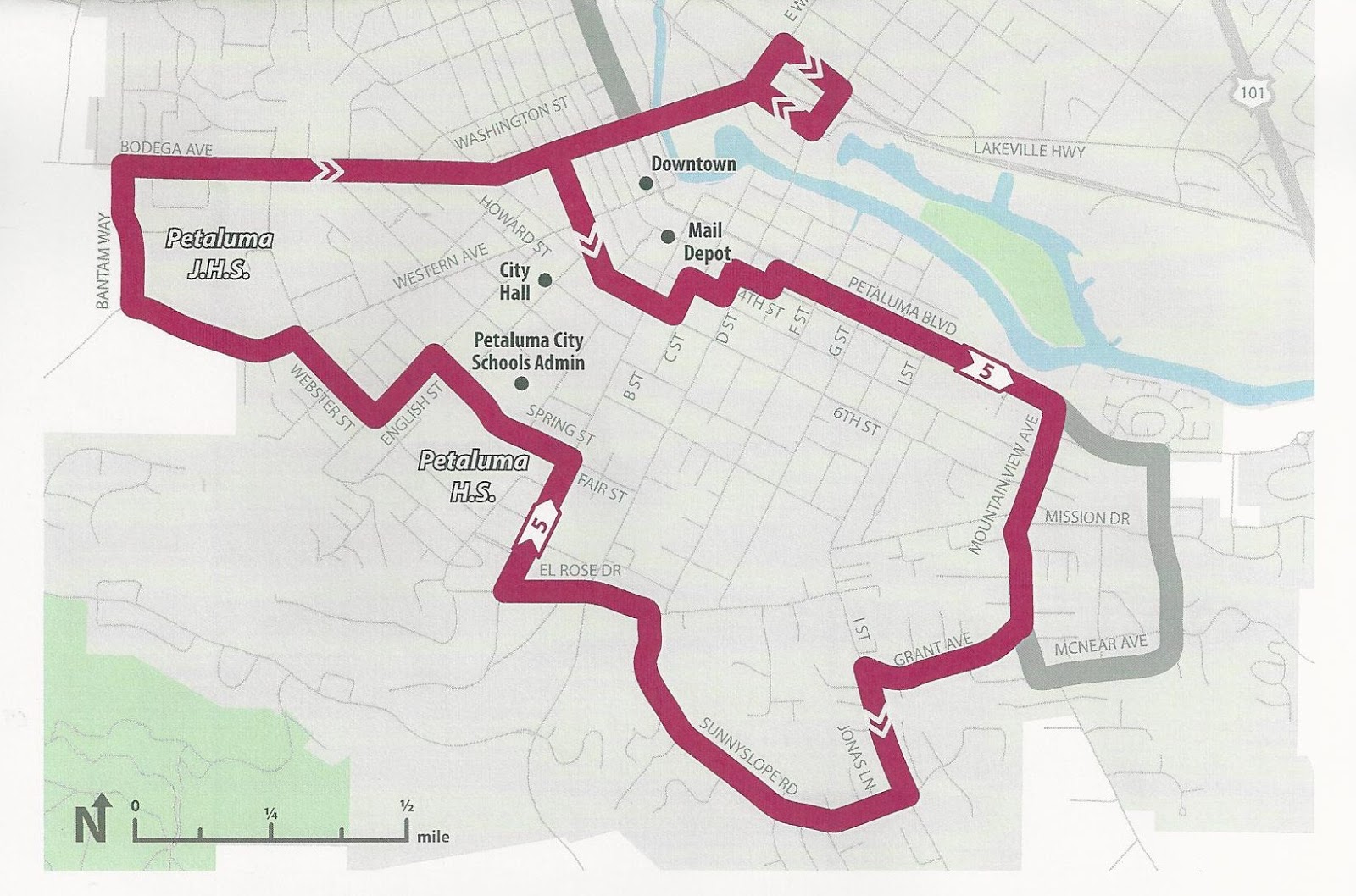
Proposed realignment of Route 5
After mixing and matching the data, the transit staff proposed a new bus stop near the SMART station along with modifications to current Routes 1, 5, and 24.  (As an aside to my Twitter followers, you may remember a recent Sunday morning when I was forced to defend the honor of Petaluma Transit against barbs from around the country directed at the drunken sailor path of Route 24.  My primary response was that the route was a temporary response to a land-use action that had ignored transit.  Sure enough, Route 24 would be tidied up under the current proposals.)

The modified routes would serve a number of anticipated SMART riders, from numerous westside residents who have told Petaluma Transit about their plans to ride SMART to St. Vincent High School students who live in Marin County and plan to ride SMART to Petaluma.

Of course, the modifications also have negatives, from tapping reserves to reducing service to a major shopping center.  Particularly painful to transit staff is ending convenient service to residents of a senior living community who have only recently become enthusiastic transit riders.  But within the limited funding typically available to transit agencies, hard choices must always be made.

The current proposals may not be the realigned routes that are eventually adopted.  Everyone involved remains open to further ideas.  But the current proposals are a powerful step toward making SMART successful.  Credit is due to the Petaluma Transit staff who are bringing them forward.

All are welcome to attend the meeting of the Petaluma Transit Advisory Committee, whether to learn more about the route modifications or to become part of the process.  The meeting will be held on Thursday, February 4, convening at 4:00pm.  The committee meets in the Council Chambers at Petaluma City Hall, 11 English Street.  I hope to see many familiar and new faces.

In my last post, I wrote about the upcoming hearing of the California Public Utility Commission on the proposed Jennings Avenue pedestrian crossing over the SMART tracks.  In my next post, I’ll provide a post-hearing update.

As always, your questions or comments will be appreciated.  Please comment below or email me.  And thanks for reading. - Dave Alden (davealden53@comcast.net)

Wednesday, January 27, 2016

You Can’t Have Any More Toys Until You Take Care of the Ones You Already Own

Alignment of proposed Rainier Connector
Consistent with their goal of promoting stronger, more financially resilient communities, StrongTowns has launched an initiative targeted toward transportation planning.   It’s a topic with which I have long familiarity.

A decade or more ago, my since-departed father noted to me that, for the first time in the better part of a century since highways and freeways were first conceived, Caltrans had no new freeway routes on their drawing boards.  There were improvements to existing routes in design, but any new routes remained in advance planning, years from design and construction, if they ever progressed that far.

Although he’d spent his career in freeway bridge design and construction, I don’t think my father was unhappy with the new status, but he was perplexed by it.  As a post-war hire at Caltrans, he’d been inculcated in the vision that there would always be new freeways to build, making Californian lives ever more convenient and freedom-filled.

His belief in that vision had perhaps begun to weaken, but it was still a change in perspective to realize that no new California freeways would likely open during the remaining years of his life.

I can appreciate his disorientation.  This past summer, I chatted with a high school classmate about our shared hometown, a car-oriented suburb of Sacramento.  We shared recollections of extensive freeway projects that were planned to slice and dice our community during our school years, although none of the projects ever came into being.  For those who aren’t of a certain age, and my high school days were 45 years ago, it’s hard to grasp the certainty we once had that freeway expansion was inevitable and would continue forever.

Given what we now know about the difficulties of funding the long-term maintenance of freeways, it’s a good that that the freeway romance cooled when it did.  But, like many ill-fated romances, it went on too long and left behind too many hard-to-break habits.

For one, even if we’re no longer envisioning four controlled-access lanes from Santa Rosa to Sonoma or from Novato to West Marin, we still spend too many of our transportation dollars on freeway widening and interchange projects, adding to the maintenance burden for the future by providing new improvements to be maintained and by not directing the now available dollars to current maintenance needs.

The problem is we justify these improvements based on the new traffic that was induced by the initial freeway construction and will soon find the new capacity similarly consumed by induced traffic, leaving us no better off.

As an example, I recently wrote of nearly $200 million in freeway improvements currently underway near Petaluma, even as the transportation system within the town continues to unravel.

As another ill-advised habit, even when we don’t look to freeways for urban and suburban traffic solutions, we still build wide arterials expecting them to solve traffic problems, only to again be stymied by induced traffic while digging deeper maintenance holes.

Recognizing the fatal popularity of ever more and ever wider roads, and concerned about the ever deepening maintenance burden being created, StrongTowns is kicking off a NoNewRoads program, highlighting the need to develop reasonable and fundable plans to maintain the roads we already have before adding more roads, lanes, or interchanges.

It won’t be an easy battle to win, as exemplified by a local chapter of the American Planning Association, folks who really should know better, giving an urban design award to a freeway interchange which isn’t urban and doesn’t make much accommodation for either pedestrians or bicyclists.  A list from Eric Jaffe from CityLab of the twelve worst freeway projects now under consideration across the country further emphasizes the extent to which we’re enamored with freeways.

As if on cue, Governor Jerry Brown, in his State of California message, noted the need for extensive freeway maintenance work.  His staff estimated that there is $77 billion of work to be done in his state alone.  (For those reaching for calculators, that would be about $2,000 for every one of the 38.8 million Californians, or about $5,000 for an average household.  It’s not an impossible burden, but still a significant chunk and doesn’t include other infrastructure elements such as water, sewer, and storm drainage.)

Consistent with his laudable goal to build a rainy day fund to tide California through the next economic challenge, Brown refused to make any of the current budget surplus available to tackle the deferred maintenance, instead calling for new fees.  (As someone who came of age during Brown’s first two terms as California Governor, with the signature of the man then known as Governor Moonbeam on both of my university diplomas, it’s odd to see Brown as the most mature adult in the room.)

At the other end of the spectrum, a Petaluma Councilmember wrote an editorial in the local paper (link not yet available) exulting that the funds had been assembled to proceed with the construction of the Rainier Connector, an arterial project that will someday be a logical connection within the city’s transportation system, especially given its proximity to the Petaluma Transit bus yard, but seems woefully premature given the state of the city’s streets.

Celebrating funding for the Rainier Connector is akin to bragging about bringing home a new car to a frontyard filled with aging cars disabled for the lack of new tires and fuel water pumps.

I applaud StrongTowns for their NoNewRoads efforts and will support them with enthusiasm.  But I’ll also note that success, at least in the near term, seems unlikely.  Perhaps we’re no longer looking at building new freeways through every city and town, but the remnants of that attitude are still deeply entrenched.

Next time, I’ll switch to pedestrian advocacy, writing about an upcoming hearing in Santa Rosa that casts a light on how we view alternative pedestrian risks and how we should facilitate more pedestrian activity.

As always, your questions or comments will be appreciated.  Please comment below or email me.  And thanks for reading. - Dave Alden (davealden53@comcast.net)

Friday, January 22, 2016

Unwinding by Playing at Art Critic

Water Street
Life has been full over the last few days.  Encouraging folks in the North Bay to attend the recent Urban Community Partnership / StrongTowns / Urban3 meetings in Santa Rosa, participating in the meetings myself, and beginning the foundation for next steps, all while feeling a bit under the weather.

There’s a need to begin talking about those next steps, but not today.

Instead, I’m going to give myself a break by undertaking a job for which my qualifications are remarkably limited.  The job of art critic.

Like a growing number of communities, Petaluma requires many types of development to include public art.  Some developers prefer not to enter the art procurement business, so instead make in lieu payments to the City.  Those funds are to be spent by the Petaluma Public Arts Committee in acquiring and installing public art in the community.

Water Street from Balshaw Bridge
As the result of several developers making in lieu payments in recent years, the funds have grown and the committee has been working toward selecting an art project.

For a location, the committee picked Water Street, along the bank of the Petaluma River a short block from the heart of downtown.  The location is appropriate, with Water Street representing the long history of Petaluma from the days when most commerce was conducted by river, through the time when railroad tracks, still in place, carried freight trains to waterfront warehouses, to the present in which Water Street has been gussied up for public use but still needs more businesses fronting on it and more people walking about.

After winnowing more than a hundred submittals down to progressively more manageable numbers, the committee recently convened to see presentations from the final four artists.

At the urging of a couple of committee members, I sat in the audience for the presentations.  And like any citizen, I soon found myself assessing and weighing the competitors.

The local newspaper, the Argus Courier, provided photos that I’ve copied here.  Here are my thoughts, in the order the presentations were made.

Icarus from the Argus Courier
Icarus: I enjoy whimsy in public art.   Icarus, with the two legs extending upward from the water, fighting to find balance, is easily the most whimsical of the final candidates.  But the choice of fiberglass as a material didn’t impress me and I agreed with the concern of another observer that the legs would become an inviting target for senior class pranks.

However, my biggest concern was the artist’s vision that legs should float up and down with the tide.  I agree with the vision, indeed I’d consider it essential, but with the river becoming nearly a mudflat at low tide, the mechanics of floating the legs becomes problematic.  Even as the artist was speaking, the engineering part of my brain was thinking of solutions involving stilling wells, float switches, and positioning motors.  But the logistical and maintenance issues would be significant.

Whirlibird from the Argus Courier
Those concerns, plus the jurisdictional issues of installing improvements within a public waterway, sank Icarus for me.

Whirlibird: With forms based on the wing of a clapper rail and the drift pattern of a maple seed pod, there was much to like about Whirlibird.  But it felt too fine-featured for a setting that was more bustling and robust in its history.  And including gearboxes so pedestrians could slowly rotate the art didn’t help the feeling of prissiness.  Whirlibird might be my favorite piece in a museum, or even in a reduced scale in my parlor, but it didn’t feel right on Water Street.

Sculptural Knot Forms from the Argus Courier
Sculptural Knot Forms: Sculptural Knot Forms was the far extreme from prissiness with a robust depiction of the knots that represent the marine history of the river.  But the work felt too simple, lacking the intrigue of the other contenders.

Vertical River: I quickly fell in love with the plastic chain mail to be used in Vertical River, supposedly developed to meet the costumer designer’s need for “The Lord of the Rings”.  A video of the material in use at a Los Angeles installation closed the deal.

Vertical River from the Argus Courier
And, nearly as quickly, I was unsold.  The proposed installation alignment, offset from the current railing and running over the river, is an improvement over the initial thought of hanging the material below the concrete deck, but still seems too isolated from the pedestrians on Water Street.  It would provide a fine experience to kayakers on the river and walkers on the nearby Balshaw Bridge, but I don’t want public art that plays to only a portion of the target audience.

My Favorite: When I first began thinking back over the four contenders, I expected to pick Whirlibird as my favorite.  But as time passed, my thoughts increasingly turned toward Sculptural Knot Forms.  Although not completely sold on the work, the simplicity eventually spoke to me, telling me that it was consistent with the setting.  This became a time when I chose to trust my slowly mulling subconscious over my first impression.

Other Thoughts: I picked a favorite because it seemed the honorable thing to do.  But I could still dream about the plastic chain mail of Vertical River; perhaps something like rings of chain mail mounted on the perimeters of platforms below the knots, simultaneously evoking the human endeavor of marine commerce and the eternal wind-rippled surface of the river that sustains it.  But it’s beyond my pay scale to suggest artistic collaborations.

The Public Weighs In: A week ago, the Argus Courier asked Petalumans for their thoughts on the four alternatives.  After I finished with my comments above, I checked the results.  More than half of the respondents voted to toss all four and to start anew.  The paper’s editorial concurred.

Given that the committee began with more than a hundred submittals before winnowing the field to the final four, I find it naïve to suggest that better alternatives are out there.  I suspect the public vote says more about art needing time to be savored, much as it took me a week to decide that Sculptural Knot Forms was my favorite.

As long as they avoid the problematic Icarus, I’m fine with the committee selecting any of the other three.  Regardless of the choice, the public will likely develop fondness over time.

Next time, I’ll offer my thoughts in the aftermath of the Santa Rosa meetings, both about the meetings themselves and about next steps.  On the latter topic, I suspect the meetings dislodged some boulders from the top of the suburban paradigm slope.  Now, it’s up to us to decide if we wish to stand at the top of slope, watching the boulders bounce toward the valley floor, or to begin prying more boulders loose, in hopes of triggering a paradigm-shifting rockslide.  Not surprisingly, the latter is my preference and I hope others will agree.

As always, your questions or comments will be appreciated.  Please comment below or email me.  And thanks for reading. - Dave Alden (davealden53@comcast.net)
Monday, January 11, 2016

StrongTowns: Digging Deeper into the Information Trove

Downtown Petaluma
Background: With the only exception being a time-out for New Year’s resolutions, my last four posts (one, two, three, and four) have been about encouraging attendance at a series of upcoming meetings on financially sustainable development in the North Bay.  It’s a pitch that will continue today.

But instead of repeating the logistical information for the meetings one more time, I’ve created a page with the key data.  (Please note the meeting times have changed since earlier communication and are now 6:00pm.)  Please share the page with others, encourage attendance, and check with me if there are questions.

Back to the sales pitch.

StrongTowns and Urban3 will be presenting at the meetings.  However, perhaps unfairly, my focus has been primarily on StrongTowns.  I love the data crunching done by Urban3, but I still look to StrongTowns for my urbanist thinking.  In part, it’s because StrongTowns is a non-profit advocacy group while Urban3 is a consultant.  In part, it’s because I’m a StrongTowns member.  But mostly, it’s because StrongTowns has a wealth of pertinent and motivating material on their website, from StrongTowns staff and StrongTowns members.

Sometime around my 45th birthday, I found myself thinking differently when gift-giving occasions approached.  When folks asked what I wanted, I still had ideas about books, music, or clothes to suggest, but what I really wanted was time.

Not more years at the end of my life, although I wouldn’t turn those down, but more hours in the day.

Time enough, after the daily commitments to work and family were covered, to partake of the ever-growing wealth of information that was so beguiling.  Time enough to ensure that I was as well-prepared as possible when I chose to espouse a cause.  Time enough to become the best-educated advocate I could be.

Digging through the StrongTowns website reminds me why I feel that way.  Everywhere I look are blog posts and articles that I want to read.  The site is filled with materials, sometimes theoretical musings and sometimes fact-based analyses, that complement the StrongTowns philosophy about what makes financially sustainable cities.

So today I’ll be lazy.  Rather than doing my own thinking, I’ll share five posts that engaged me during my most recent foray into the StrongTowns website.  I was attracted to the posts for different reasons, some because they mirrored issues in my own community, some because they asked questions that I’d once asked and since found answers, and some because the intellectual musings felt insightful to me.

Here we go.

Michael and Jennifer Smith write about the water system in their town of Rockford, Illinois.  They explain how it will be thirty years before the water pipes have passed their useful life today have all been replaced, by which time an even greater number of miles of pipe will need replacement.  It’s a story that can be told about most U.S. cities, including my town, but hearing a familiar story told about a town 2,000 miles away creates a sense of community with those who argue for the StrongTowns thinking.

Chuck Marohn of StrongTowns, using Mankato in his home state of Minnesota as an example, highlights the fallacies that often underlie transportation planning decisions.  Those in my town may note similarities to the on-going discussion about the Rainier Connector.

Tony Dutzik makes the same point on a grander scale, noting that for all the funding now flowing toward transit, the great preponderance of funding still goes to freeway projects.  He notes the somewhere Robert Moses is smiling, an image guaranteed to raise hackles on many, including me.

Daniel Day from San Antonio asks why buses often stop on the street rather that at the entrances to malls.  It was a question that once puzzled me until a grizzled transit vet explained the facts of transit life.  I shared my acquired wisdom as a comment to the post.

Lastly, I return again to Marohn for his musings on the nature of change, musings that include defending the role of cancer as an occasional unfortunate byproduct of essential change and quoting Charles Darwin on the process by which new ways of thinking are slowly accepted.   They’re the kind of musings that I sometimes, perhaps self-indulgently, offer in this blog, so I enjoyed reading as Marohn wandered down a similar path.

Although the posts collectively provide insightful information in considering the future of cities, they also show a community of aligned souls, willing to devote time and effort to the cause of a better future.  Both facets are inspiring.

In my next post, I’ll recall a criticism of StrongTowns that was made to me a couple of years back and to which I never responded adequately.  Perhaps being a couple of years wiser, I’ll take another run at refuting.

As always, your questions or comments will be appreciated.  Please comment below or email me.  And thanks for reading. - Dave Alden (davealden53@comcast.net)